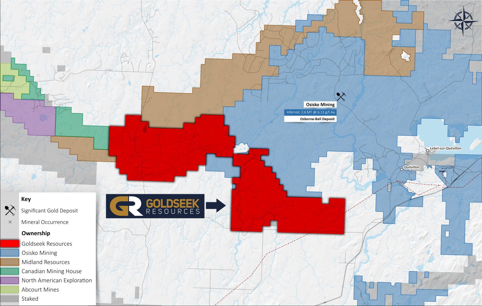
In 2020, Goldseek acquired the Quevillon West Property whch is located 35km west from Lebel-sur-Quevillon and 60km north of Amos. It is accessible by a well-maintained dirt road as well as logging roads. The 497 claims cover approximately 27,156.69 hectares (271.55 km2).
The Property is located between the Sleeping Giant Mine (Abcourt Mines) and the Osborne-Bell Deposit (Osisko Mining). The Quevillon West Property appears to follow the same greenstone belt and structures that connect these two deposits
Targets
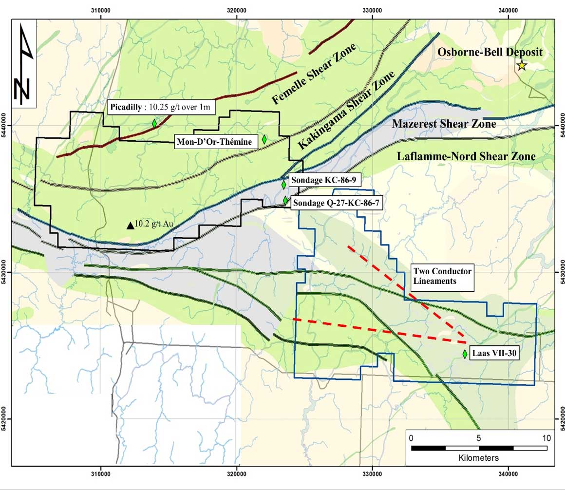
- The Maizerest shear zone located at the contact between the Glandelet Formation (sediments) and the Vanier-Dalet-Poirier Group (volcanics). The contact was also defined as an exploration target by the Ministry of Energy and Natural Resources (“MERN”). A grab sample located close to the contact assayed 2 g/t Au.
- The Vanier-Dalet-Poirier Group, which is made of andesitic rocks and felsic tuffs. The group includes, west of the Property, the Sleeping Giant mine, operated by Abcourt Mines. The mine has a reserve estimate dating 2018 that shows measured and indicated resource of 486,500 tons @ 11.20 g/t Au (Abcourt, 2018). The Group also hosts, east of the Property, the Osborne-Bell gold resource of 2,587,000 tons @ 6.13 g/t owned by Osisko Mining (Osisko, 2018). The Picadilly showing is located in this Group, north of the Property, and assayed 10.25 g/t over 1m and also 1.08 g/t over 1m. Some more showings are hosted in that Group and are located on the Property: Mon-D’Or-Thémine (1 g/t over 1.0m); Sondage KC-86-9 (82 g/t Au (+- Zn and Cu) over 0.2m) and Q-27-KC-86-7 (0.65% Zn + 0.11% Cu over 0.97m). A review of the geochemistry revealed on the Property an anomalous area in gold and base metal inside this Group.
- Two other shear zones of significance are found on the northern part of Property. The Femelle and the Kakingama shear zones pass through the northern claim block. These shear zones are manifested by intense stretching lineaments, an increase in schistosity and the presence of numerous quartz-chlorite-carbonate-(albite)-(pyrite) veins (Hammouche, 2017)
- Faults related to the Laflamme shear zone are located on the eastern claim block, which was newly acquired (See news release dated June 26, 2020). The Laflamme Nord fault is also a target defined by the MERN.
- A sulfide horizon is present in that same area of the Property and is named the Laas VII-30 showing (35% Cu over 0.12m). This horizon is described as 26m of pyrite and pyrrhotite mineralization associated with anomalous base metal content. The Company believes that the strike extension of this horizon could host additional base metals and/or gold mineralization. Two conductor lineaments (Geotech, 2017) cross-over just north of that mineralization. A review of historical data also allowed to define a Cu, Zn, Pb sediment anomaly in the area down ice from that horizon. These aspects indicate that potential polymetallic massive sulfide mineralization could be hosted along the strike of the currently known sulphidic horizons.
A systematic till sampling survey will be performed to test the multiple targets found on the Property. The glacial drift direction and regional strike of the geological units will allow a general assessment of the Property with the till sampling program. The assay results should indicate to the Company if mineralization can be found at surface over the defined targets. Upon results, the Company will continue its exploration program using geophysics and drilling.